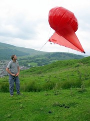
The ultimate approach to land mapping, fast topographic survey generation, photographing archaeology etc. is low level aerial photography. We have experimented with many platforms and found excellent solutions from no wind (helium balloons) through to strong winds (kites: kite aerial photography (KAP)). We have also identified several camera hardware solutions that can be calibrated and routinely used for low elevation aerial photogrammetry.
Aerial Photography Services: we can also offer a service to acquire imagery from various elevated platforms. This may be ideal if you have a one off application. Click here for further details
For use in conjunction with our range of aerial photography platforms (masts and balloons), we have compiled a reliable list of camera modifications and adaptions to enable remote photography. These include interfacing with your existing digital SLR
(fixed focal length lens is mandatory for photogrammetry), and an 8.5 megpixel compact camera that is very lightweight.
We have experimented with several Kite Aerial Photography (KAP) solutions. A selection of his images acquired for both artisitc purposes as well as aerial imaging can be viewed here. He will be delighted to share his experience and suggestions for aerial
platforms with anyone interested – it’s much cheaper than a helicopter!