TerraGeomatics provides a comprehensive service for individuals and companies who require reliable, high quality survey solutions.
Using our state of the art software and instrumentation, we can produce data for a fraction of the cost of conventional methods, which makes repeat monitoring surveys, or surveys in remote regions a real possibility.
* Photogrammetry picks up a level of detail that can not be obtained through any other surveying technique.
* Return visits to pick up missed detail are reduced.
* Reduction in costly field time.
* Drawing production is fast, accurate and easy because pictures of the object are always available to identify features accurately and completely
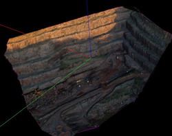
* Sites with difficult or hazardous access can be surveyed in complete safety. (ie bridges, high traffic areas, or the cliff above)
* Drawings are in 3 dimensions (ie height of cliff) * Photogrammetry provides a flexible level of accuracy to suit user needs.
* The more detail on the site to be surveyed, the easier it is to survey the site.
* Photogrammetry provides a supplemental products as part of the drawing production. For example aerial photographs or site photographs.